Gilf Al Kebir
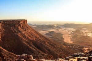
Gilf Kebir (Great Barrier) dominates Egypt’s remotest corner. The 7,770 km2 plateau forms an obstacle that is even more formidable than the Great Sand Sea. It was discovered in 1926 by Prince Kemal El-Din, Before this, the Gilf was only known to desert nomads who found no reason to share this knowledge with outsiders.
Gilf Kebir is known for its rugged beauty, its remote and deserted atmosphere, and its interesting geological history.
Another point of interest here is the dramatic cliff paintings. A series of pictographs, rock carvings, and petroglyphs decorate the landscape, depicting an early era of abundant animal life and human habitation.
Later, when European travellers explored the area, their finds illuminated Saharan prehistoric life and inspired the book and film “The English Patient” which relates the exploits of explorer László Almássy and his discovery of the Cave of the Swimmers.
This beautiful example of prehistoric rock art is one of the thousands of paintings and petroglyphs found in the wadis, or valleys, of the Gilf and Jebel Uwaynat. These paintings depict giraffes and ostriches, lions and cattle, people hunting and swimming, and give an overall image of prehistoric life before the shift from Savannah to Desert which occurred at the end of the Holocene wet period, around 5000BC.
Gilf Kebir, since this decisive shift, has become one of the driest places on Earth and is essentially inhabitable. Rainfall is scarce, with less than a millimeter a year, and sometimes doesn’t fall for up to five years. Temperatures range from 0OC to 42O C (32- 108OF), and there can be up to a 30C difference between night and day. With colossal dunes leapfrogging each other to climb the 300m (984 ft) escarpment, it has been named one of the places in the world where the environmental conditions are closest to that of the surface of Mars and have been studied extensively by NASA. It is an almost alien landscape, rock paintings and multi-hued sand make Gilf Kebir an ideal location for nature-based photography.
Yet eons ago, in the late Tertiary age, Gilf Kebir was a watershed, draining in all directions. Its valleys were eroded by the water and weathered by the wind and sand over one hundred thousand years. The sheer cliffs on the south and southwest sides are the highest, towering over the northeasterly ones, which have been worn down by The Sand Sea.
Dunes have now filled up the valleys, the sand varying in colour depending on their location. White sand is found around the Sand Sea, red around the middle of the Gilf and its southern massif. Despite having little to no rainfall, hardy flora and fauna are able to survive: Barbary sheep, gazelles, foxes, lizards, snakes, birds and butterflies, roses of Jericho and acacia trees. You may find other surprises, too, like the wreck of a Blenheim bomber discovered on the plateau in 2001, one of many relics from World War II.
In 2007, the Egyptian government established the Gilf Kebir National Park, it is the largest of the 27 protected areas in Egypt, whose 48,533 km2 area (18,739 miles2) it encompasses 3 different geomorphic units: the Silica Glass area of the Sand Sea, the Gilf Kebir plateau proper, and the Gebel Uwaynat massif.
What to see:
Between Siwa Oasis and the Gilf Kebir plateau lays the awesome immensity of dune fields that the explorer Gerhard Rohlfs named the Great Sand Sea (‘Bahr er-Raml’ in Arabic). Covering 72,000 sq. km. (27,799 sq. mi.) which is roughly the size of Ireland, the Sand Sea extends for an average of 650km (404 mi.) from north to south and 300km (186 mi.) from east to west. Roughly two-thirds of this consists of parallel seif dunes, sometimes towering over 100m (328 ft.) high and as much as 150km (93 mi.) long, separated by flat “corridors” of 1 or 2 km. (0.6 or1.2 mi.) wide, whose northwest-southeast alignment is determined by the prevailing wind. While these seif dunes are ever-moving, satellite imaging has shown that they sit atop stable whale-backed dunes. Elsewhere in the Sand Sea, where seif dunes have descended escarpments, they have reformed as crescent-shaped barchans. Though shifting sands seem the only “life” in the Sand Sea, a little vegetation exists, lying dormant for years until a brief shower of rain revives it.
There is also an interesting sight which is the Libyan Desert Silica Glass (LDSG), one of the great geological mysteries of the Sahara Desert.
Wadi Abd al-Malik is the largest and the most mysterious valley in the entire Gilf Kebir. It abounds in prehistoric sites and still bears traces of its original vegetation.
This is the first valley the Clayton-East-Clayton/Almasy Expedition of 1932 saw from the air but was unable to find on foot. They were sure that it was Zerzura. In 1938, Bagnold and Peel came to the Wadi Abd al-Malik to look for a well that natives said existed but Almasy was unable to find. They looked for 3 days and then Peel entered a small grotto and found some more rock art. The paintings were on both walls, dust-covered. They depicted some cattle and another animal, probably a dog. The paintings were dark red, red, and white.
First mentioned in 1246 as an abandoned village in the desert beyond the Fayoum, the “Lost Oasis” of Zerzura reappeared as a fabulous city in the fifteenth-century Arabic treasure-hunters Book of Hidden Pearls. Its setting was described as 3 valleys endowed with springs, palm trees, birds, and animals, where robbers would find a city “white like a pigeon”, with a bird carved on its gate. Inside were riches, and a king and queen asleep in their castle. “Do not approach them, but take the treasure”, the book advised. After the nineteenth-century Egyptologist, John Wilkinson learned of the story, the search for Zerzura intrigued European explorers, who soon became obsessed with the tale. As successive desert surveys dashed hopes of finding it anywhere within reach of the known oases, attention turned to the far south, to Jebel Uwaynat and the Gilf Kebir.
The red sand dunes of the Wadi Hamra (Red Valley), cascading down the side of a black mountain is a beautiful sight, especially for avid photographers wanting something more abstract to capture. It is considered the most beautiful valley in the entire Gilf Kebir region.
However, the presence of vegetation and wild animals means that access to this valley is necessarily limited.
It is said that Almasy wanted Rommel to land troops on top of the Gilf and bring them down into Wadi Hamra. Within the Wadi Hamra are three groups of rock art sites. All of them are engravings, in a fairly crude state, and depict wild fauna. Based on the style and state of weathering they seem to belong to the earliest phase of rock art in the region.
Wadi al-Bakht (Valley of Luck or Chance) was first explored by O. H. Myers in 1938. Four distinct concentrations of artifacts were identified. People lived in this valley for many centuries. The entire area, including the dune face, is littered with ancient artifacts. There are grinding stones, pottery, ostrich eggshells, and bones. 2 km (1.2 mi.) beyond it is a Neolithic site. In all probability, the people lived on the dune first and then ventured closer to the lake for settlements. Pottery is abundant
, mostly dating back to 6930 BC. There is also evidence that the settlers of the time owned cattle.
During WW II, the British laid out an airport in this broad valley bounded by a series of eight bell-shaped hills, whose remains are still in good condition.
Magret el-Kantara (Shaw’s Cave or Shelter) is decorated with extraordinarily beautiful paintings, mostly of cattle, a testament to the high artistic level achieved by the Neolithic pastoral culture of the Gilf Kebir region.
Cave of the Swimmers &Cave of the Archers in Wadi Sura (Picture Valley) is the most famous site in the Gilf Kebir region, because of the Swimmers’ Cave.
The Cave of the Swimmers harbors well over a hundred figures in diverse styles. Its famous swimmers are 10cm (4 in) long and painted in red, with small rounded heads on stalks, tadpole-shaped bodies, and spidery arms and legs. Some are diving, implying that a lake once existed here (for which there’s also geological evidence). The second group of figures is depicted standing, with clumsy limbs, thick torsos, and pea-shaped heads; hands only appear on the larger figures. Most are dark red, with bands of white around their ankles, wrists, or waists. Still more intriguing are two yellow figures that seem to be stretching out their arms to welcome a third, smaller, redone, which may be a child and its parents. Cattle, giraffes, ostriches, and dogs are also depicted on the walls.
The Cave of the Archers contains dark red and white figures of naked men clutching bows, some of them shooting at cattle – whose presence dates these pictures to the Cattle Period (5000–2500 BC) of North African rock art.
On the western side of the Gilf Kebir are more Wadis, many of which have not yet been explored much, or even given names.
In February 2001, Werner Lenz and the party found a beautiful shelter some distance from the Wadi Sura proper, which contains a series of very well-preserved overlapping scenes of several periods (including faint engravings that were painted over, and some small erased figures of the ‘cave of swimmers’ style). On the ceiling, there is a unique scene of two negative hands, the colors as vivid as if they were made yesterday.
In the March 2003 Fliegel Jezerniczky expedition, a small shelter near the white-painted cattle was found and reported by Gauthier and Negro. It contains a scene of calves tethered to a tree, in a style identical to that at Jebel Uwaynat.
THIRD UNIT: GEBEL (JEBEL) UWAYNAT:
On a map of North Africa, the ruler-straight borders of Libya, Egypt, and Sudan intersect at Jebel Uwaynat, the highest, most isolated point in the Libyan Desert. Surrounded by sand sheets, it rises about 2,000 m (6,562 ft.) above the desert floor, just high enough to attract a little rainfall (600m above sea level)(1,968 ft.), which percolates down to small pools or “springs” at its base, after which Uwaynat is named.
The valleys here (called karkurs) are fertile with water, and sustained communities from prehistoric times until the early 1930s, with rock art spanning thousands of years.
In Karkur Talh (Acacia Valley), there are over 4,000 rock art sites, thus making the locality an open-air museum of inestimable value. It has engravings of lions, giraffes, ostriches, gazelles, cows, and 90 human figures. These figures lead Winkler to conclude that both were the work of the ancient Tebu, who ranged across the Sahara from their mountainous homeland of Tibesti, in Chad (as they still do today).
The climate:
The almost total absence of rainfall, and the high maximum temperature between day and night, all make this an inhospitable region. But this is not always the case: in fact, many months are suitable for visits to this region, like from October till March.
Gilf safaris:
Jeep-safari to the Gilf is a major logistical effort involving multiple 4WD vehicles equipped with GPS and satellite phones.
Security is a consideration for anyone traveling this way. Discomfort is inevitable: sand gets into every crevice of your body, there’s no water to spare for washing and you start to smell, like everybody on the safari. Unless you’re willing to rough it and muck in when needed, this is not for you. However, it is an experience you will remember for a lifetime.