The Red Sea and Sinai
- HurghadaHurghada is a beach resort town stretching some 40km along Egypt’s Red Sea coast. It’s renowned for scuba diving and has numerous dive shops and schools in its modern Sekalla district. There are many restaurants, bars, and nightclubs on the NEw Marina, while the old town, El Dahar, is home to traditional Egyptian coffee shops and souks. perfect all year round weather, beautiful beaches, great streetlife in Sakala, Hurghada’s long stretch of sandy beach is lined with resort hotels. Elgouna is North of Hurghada and is a self-sufficient gated city, which also has 5-star hotels inside. Sahl Hasheesh is to the south of the city and is also a gated city but still in development, 5 star hotels, beautiful beaches but not much else as yet. What to do: Diving: Hurghada dive companies have something to offer the beginner to the professional, we can help you organise a beginners course or recommend the best companies, Desert safari quad bikes Hurghada is surrounded by desert and mountains and as such is perfect to spend a day on safari with quad bikes, camels, bbq meal outside around a campfire (full day ) half day tour Before starting your trip to the Bedouin village, you will get some explanations about how to use the quads and give you some safety rules to take into consideration. Now it is time to experience a thrilling ride through the sand dunes to a Bedouin village. The ride takes about 1 hour. Once you arrive at the Bedouin village, a delicious black tea, made in the traditional way, is served and you will have the opportunity to ride on a camel. You can walk around in the village and discover how they are living. After having been there for about 1 hour, it is time to climb back on your quad and go back to the station. Let the desert flash past you, conquer the dunes and feel the adrenaline rush. At the station, a jeep is waiting for you to drive you back to your hotel. Enjoy riding a quad and exploring the desert during this 3 hours driving ATV tour. Most resorts in Hurghada have their own aqua park but if you would like to go to a large aqua park that can be arranged, jungle park or titanic resort both have large aqua parks City tour- City tours are very popular in Hurghada due to the distance between resorts and sites, The Cathedral of Saint Shenouda is in the El Dahar area of Hurghada. The cathedral looks fairly modest on the outside. However, inside definitely showcases some gems. These include stunning stained glass. Plus beautiful, hand-painted ceilings. Al Mina Mosque is near Hurghada marina. The mosque sits perfectly on the waterfront. This white marble building has two show-stopping minarets. Plus the ornate, decorative carvings are extremely impressive. In addition a drive through the old and new parts of Hurghada give you a feeling for this city. Hurghada Museum opened in 2021 From 10:00 To 13:00 From 17:00 To 22:00. It’s the first antiquities museum in the Red Sea Governorate. It’s located south of Hurghada near the Tourist’s Promenade and Hurghada International Airport. The museum was built upon ten thousand square meters of land, the museum’s building has been built on three thousand square meters and is very eye-catching. The Museum endeavors to emphasize beauty across different historical periods in Egyptian history. It will present this theme to visitors in an appropriate manner through the means of an attractive museum scenario. Hurghada Grand Aquarium Hurghada Grand Aquarium is dedicated to inspiring guests of all ages to appreciate the marine environment while promoting conservation action and developing an understanding for the irreplaceable value of all life in our world’s ocean. By teaching children and adults the importance of conservation, ecology, and stewardship, we believe they will apply this knowledge to make sustainable choices and take an active part in preserving our marine environment.
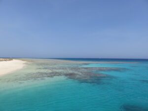
- Sharm El SheikhA well-known tourist location in South Sinai. A year-round beach resort, Sharm El-Sheikh is a pleasant place to visit in both the summer and the winter. Easily one of the most accessible and developed tourist resort communities in the Sinai Peninsula, the city is surrounded by mountains and the sea, as well as Bedouins and their traditional colourful tents. Sharm El-Sheikh is famous for its crystal-clear waters, rare and lovely reefs, and an incredible variety of exotic fish darting in and out of the colourful coral, thus making this a snorkelling and scuba-diving paradise. It is also a great destination for families who want to bring their little ones to Egypt for a beach holiday. What to see: Tiran Island and Ras Mohammed National Parks Na’ama Bay Sharm el Sheikh Museum Old Market and Al Sahaba mosque The Heavenly Cathedral Farsha Cafe About 20 km(12 miles) West of Sharm el-Sheikh, overlooking the junction of the Gulf of Suez and the Gulf of Aqaba, is the Ras Mohammed National Park. Possibly one of the world’s most spectacular coral reef ecosystems, the national park includes a wealth of coral species and teeming marine life. There is also a diversity of desert habitats such as mountains and wadis, gravel plains and sand dunes. Sea-grass and mangrove trees make up the majority of the flora here, with over two hundred species of corals, around a thousand species of fish, forty species of starfish, twenty-five species of sea urchins and one hundred and fifty species of crustaceans making up the fauna. Other activities: Discover the life underwater coral reefs and enjoy all day on the boat with scuba diving and snorkelling excursions. Diving Safaris offer short and long diving tours, which can be tailor-made to fit your experience levels. Enjoy 90 minutes in a semi-submarine seeing different reefs, corals and coloured fish. One of the best places to see the beauty of nature is the Coloured Canyon, where you can enjoy a day jeep safari. Discover the Bedouin life, take a tour on a camel and enjoy Bedouin tea and the atmosphere of the Bedouin Tent with the camel safari. Visit Saint Catherine Monastery and hike Sinai Mountain (also known as Gebel Musa / Moses Mountain). You can also extend your trip by travelling to Petra, where you can visit the Roman theatre and the ancient tombs of Petra. The duration of this tour is around sixteen hours, starting at 5:00 am and ending at 9:00 pm.

- Saint CatherineSaint Catherine is a city in the South Sinai Governorate of Egypt Venerated by Christians, Jews and Muslims as the site of God’s revelation of the Ten Commandments, St Catherine is where Moses is said to have heard God speaking to him. St. Catherine is a Protected Area as a World Heritage site, covering 5,750sq. km (1,062sq. miles). Despite its high altitude St. Catherine, supports a surprising diversity of wildlife, some found nowhere else in the world. The protected area also includes the highest mountains in Egypt. There are around 1,000 plant species, representing almost 40% of Egypt’s total flora. Out of the 46 reptile species, 15 are found only here. Other species include geckos, agamids, skunks, hedgehogs, hares, Sinai leopards and rock hyrax. What to see: St Catherine Monastery, founded in the 6th Century AD, is a Greek Orthodox monastery with a rich heritage in architecture and art that draws pilgrims from all over the world. Situated at an altitude of 1,480m (4,854 ft), the monastery sits in a picturesque gorge at the foot of Moses’ Mountain. It is famous for Moses’ well, the Burning Bush and the Icons Museum. Mount Sinai, or Moses’ Mountain, is believed to be the site of God’s revelation of the Ten Commandments. It overlooks the valley where Moses is said to have heard God’s voice from the Burning Bush. The second highest of Egypt’s mountains, Moses’ Mountain provides an unforgettable hike to its summits and offers a taste of the magnificence of Sinai’s mountainous region. St Catherine Mountain.Egypt’s highest peak, standing at 2,637m (8,655 ft). Its name is given due to the body of St Catherine being found on its peak. The plain of El-Raha, meaning ‘resting place’, is believed to be where Aaron and the Israelites made the Golden Calf while Moses was on Mount Sinai. Golden Calf is also a name given to a rock in the shape of a calf which is believed to have been the mould for the Israelites’ idol. Surrounded by a green belt of olive and cypress trees, The Monastery of the 40 Martyrs was constructed in the 6th century in honour of the 40 Christian martyrs who died in Sebaste (central Turkey). The Seven Girls’ Monastery lies in Sinai’s largest oasis – Feiran Oasis. This is believed to be the location of the biblical Rephidim, where Joshua defeated the Amalekites whilst Moses and Aaron offered prayerful support. The convent was established in the 4th Century. Halfway up the Forty Martyrs’ valley is Moses’ Rock, or Hajar Mousa. The Chapel of the Birth of the Holy Virgin sits right next to it. The rock with twelve clefts is believed to be the rock from which Moses fetched water. Saint Catherine is the central starting point for trekking and hiking excursions in the many remote Valleys of South Sinai. Many trekking and hiking excursions can be organised and led by the local Bedouins. The tour duration can vary from a few hours to many days. Sinai can be reached from Sharm El-sheikh or Dahab, with a flight from Cairo then by vehicle.
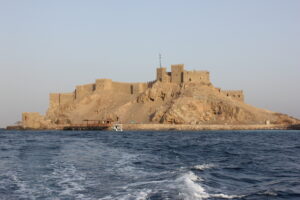
- TabaLocated on the northern tip of the Gulf of Aqaba, Egypt. Taba is the centre of a region rich in natural attractions. Taba has been a caravan route since the 14th century, serving as a meeting of borders between Jordan, Palestine, Israel and the Whole of Egypt as well as overlooking Saudi Arabia. With its warm weather, idyllic beaches and convenient location, Taba is a great place for leisure and adventure seekers alike. Taba has been a much disputed area of Sinai between Egypt in Israel. It has changed hands several times but has ended up back in Egypt’s possession in 1989. Many people visiting Taba come to experience the serene beaches and fantastic hotels that Taba has to offer. Adventure sports such as diving, snorkelling, hiking, quad, and of course camel rides are very popular and enjoyable. What to see: Taba Fort is interesting from both a natural and a historic standpoint, located on Pharaoh’s Island in the Gulf of Aqaba. Sometimes called Coral Island, or Geziret Faraun, the island is just 250 m (820ft) from the shore, and is the location of a Crusader fortress originally built by Baldwin I, the King of Jerusalem, around 1116 AD. At various times while it was in Crusader hands, Taba Fort was used to collect taxes on Arab merchants, and sometimes to attack Arab shipping, while at the same time it protected pilgrims travelling between Jerusalem and St. Catherines Monastery. The fortification was, however, captured by Salah al-Din in about 1170 AD. From the top of the fortress, one can see four countries: Egypt, Israel, Jordan and Saudi Arabia. Some biblical scholars believe that the island was the biblical Phoenician port of Ezion-Gaver. The most beautiful and striking inlet in the Gulf of Aqaba, The Fjord is a spectacular location with splendid turquoise blue waters. The road descends to the sandy beach, before going up to The Northern Side of the bay to a scenic viewpoint. The fjord lies 12 km, or 7.5 miles, South of Taba.
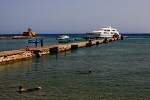
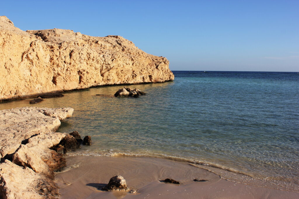
- El QuseirA charming seaside town, perfect for relaxation mixed among a busy itinerary. It is one of those unusual places in Egypt where you may go scuba diving in the Red Sea or spend a comfortable afternoon sunbathing on a pristine beach, and also visit historical sites nearby. It’s the only port on the Red Sea that has kept its Egyptian roots, keeping its original local landscape, atmosphere and culture, in contrast with the other ports, which have either adopted a more westernized style or has become a commercial harbour. Its position on the coast has made it one of the major ports of the Red Sea and was the route used in Ancient Times to transport goods to and from remote lands to Egypt. Not only this, but several civilizations over the past four thousand years have used this port as a starting point to go exploring, or to trade with other countries. It was from here that the Boats sailed to the ‘Land of Punt’. However, the inauguration of Suez Canal in 1869, led to a decay of the town. The canal created an easier way to cross the Mediterranean and because of this Al-Quseir lost its prominence as a link between the Western World and Egypt. The city’s original style and architecture are found in many buildings in town. It is represented with intricate wooden terraces and mashrabiyya, (wooden lattice screens), and in the old buildings built in the classic French and British styles, with large terraces and wooden balconies. Today, it is a quiet seaside resort with beautiful beaches, clear waters, and coral reefs, making it a lovely destination for diving. What to see: Today, nevertheless, El-Quseir is still a fishing community, and the houses hug the coastline. The town holds a market, usually on Fridays, where farmers and fishermen sell their local, fresh produce, holding up the fishing tradition of the city. The 16th Century fortress of Sultan Selim,(Ottoman Fortress), still stands in the centre of the town, it shows that El-Quseir had former strategic importance. Although the exterior wall has been altered by the French and The British, who, in a heated battle in the 1800s, fired some 6000 cannonballs at it, most of it has stayed intact. Next to the fort, dating back to 1704 is the Faran Mosque. There are numerous small lanes good for wandering around to get a glimpse of the local life. One of them, Sharia Um Saber, has been restored, to allow tourists to see the lives of the people that live here. An Old Phosphate Company was the biggest business in El-Quseir and its produce was shipped all over the world. On the site, you can see the buildings’ remains and classical buildings made for foreign engineering.
- MarsaAlamMarsa Alam has some of the best diving and snorkelling in Egypt. Marsa Alam used to be a fishing village on the Red Sea Coast. However, with the addition of an international airport, the Ghalib Marina which attracts many boats, several 5-star hotels and many new resorts and hotels it is rapidly becoming much more. By road, Marsa Alam is at the junction between the Red Sea coast road and the road from Edfu on the Nile. This road, which was probably originally built in the Greek Period, passes through some historic landscape where the ancient Egyptians mined much of their gold and where today phosphate is mined, can also be accessed by flying into Hurghada, or from Aswan. In addition, a wealth of rock inscriptions from as early as the Pre-dynastic Period may also be found along this route near Marsa Alam. The smooth rock faces were an ideal canvas for Ancient Graffiti, which dates from the earliest times right up until the present. The weather in Marsa Alam is generally comfortable. Even in summer, the refreshing breeze from the Red Sea cools down the coastline. Many excellent resorts offer a variety of accommodations sure to please visitors of all ages, making it a great destination for a holiday getaway. Port Ghaleb is a state of the art resort, including both a 1,000 berth marina and port, with a dock-side harbour, yacht club and spa, along with a highly animated town centre and a corniche around the marina area. Egypt’s most famous gold mine is in Marsa Alam. However the primary reason to visit is for snorkelling and diving. This whole coastline is one huge reef of exceptional quality. What to see: Dive and snorkelling sites in the area include: Elphinstone Reef is the legendary dive site of the south. The walls plunge deep into the blue, richly decorated with soft, bright pink, red, white and brown corals, sponges, gorgonians and fans. Pelagics often swim by the spot to feed on the abundant reef fish population, but many other species, including dolphins, fusiliers, jacks, snappers, groupers and wrasse may also be seen. The Northern Plateau is home to schooling hammerhead sharks with frequent sightings of oceanic grey / white tip sharks and reef sharks along with barracuda, numerous big Jacks and tuna. St. Johns Reef provides beautifully blue waters and a huge array of sea life. Shalateen is a border town between Egypt and Sudan. Whilst it is more Sudanese in culture and atmosphere, it will provide some variation to your trip. Shalateen is also famous for its gold mining and camel market. Abu Dabbab is a long, sandy beach with an excellent coral reef and an area of seagrass which attracts turtles and dugong. Easy entry into the water from the beach with sand underfoot and fish in the shallows makes it a good reef for beginner snorkelers or children. Marsa Shagra is one of three associated eco resorts in the area, where care for the environment is taken seriously. Its sister eco resorts are Marsa Nakari beside Dolphin House Reef and Wadi Lahami which is 10km South of Hamata village and one of the last bases to dive before the border to Sudan which lies approximately 300km further South. Marsa Shagra has an excellent house reef and a long expanse of beach, with a choice of comfortable tents close to the water edge or chalets. Focused on diving but welcoming all guests, the Red Sea Diving Safari team also take guests to all the major Marsa Alam reefs. Daedalus Reef is a huge round reef with a lighthouse of more than 65 km. (40 miles) away from the coast. It provides an excellent opportunity for spotting big pelagics all around its steep walls with an extreme variety of fish and coral. In the Fury Shoal group, the Abu Galawa Reef has a good coral garden on the north side, and a wreck of an old tug boat fully covered with corals leaning on a pinnacle on The South Side. Sataya Dolphin Reef is a barrier reef that offers a sheltered inner lagoon and sheer walls on the outside schooling hammerhead sharks, Large tuna and Jacks. Zabargat (Zabargad) is the largest of the Foul Bay Islands and has the appearance of an enormous mountain coming out of the water surrounded by a lagoon and circling reef. There are a couple of wrecks and some decent diving with a great variety of both corals and reef fish. In addition, the island itself was most probably mined by ancient Egyptians for precious stones. Rocky Island, a tiny rock emerging a few feet out of the water, offers one of the most incredible underwater scenarios of the whole Red Sea. Steep walls fall into the deep blue, currents, soft corals and a great abundance of pelagics and all kinds of fish. Wadi el Gemal, or Valley of the Camels, is a unique experience to view the desert’s attractive wildlife, flora and fauna. Hiking, quad biking and camel riding are all great options for exploring here. Shaab Marsa Alam is a large reef in front of the last Southern Civilian Town on the Egyptian Coastline. Coral gardens formed near huge coral blocks ‘porites’ and shoals of banners, goatfish, snappers and jacks. Shaab Samadai is a horseshoe-shaped reef that creates a shallow turquoise water lagoon where a large herd of Spinner dolphins live permanently. Others often show up around noon for a rest and to teach their babies how to hunt. Several dives are found on its outer walls. The Western Tip provides a large group of pinnacles rising to the surface from a carpet of seagrass, populated by schools of Reef Fish. Shaab Sharm (Gota Sharm) is a big reef with huge walls, hammerhead and grey reef sharks in Summer, Malabar grouper, barracuda, and schooling reef fish the rest of the year. Shaab Mansour (Shaab Maksur) provides good dives on both North and South Plateaus, with strong currents which favour the growth of all types of coral including black, soft and fans. There can also be sightings of sharks, Napoleon fish, and tuna.
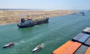
- The Suez Canal Zone & The Canal CitiesThe Suez Canal severs Africa from Asia and links The Mediterranean with the Red Sea. Watching super-tankers gliding through the desert as they ply the narrow channel is a bizarre spectacle. A hotly contested triumph of modern engineering, the canal opened in 1869 after 10 years of construction and remains one of the world’s busiest shipping lanes. The Suez Canal Corridor area is a mega project in Egypt that was launched on 5 August 2014 by president Abdel fattah El-Sisi. The project’s aim is to increase the role of the Suez Canal region in international trading and to develop the three canal cities: Suez , Ismailia, and Port said. The project involves building a new city (New Ismailia City), an industrial zone, fish farms, completing the technology valley, building seven new tunnels between Sinai and Ismailia and Port Said, improving five existing ports, and digging a new canal parallel to the Suez Canal. The new canal will increase the canal capacity by allowing ships to sail into both directions at the same time for a greater proportion of the canal. The project will transfer the canal cities into an important trading centre globally. It will also build new centres on the Suez Canal for logistic and ship services. This project was completed in January 2016. The project is also known as “The Great Egyptian Dream” because it will help the economy of Egypt after many years of unrest and corruption. The canal is an artificial sea-level waterway running north to south, stretching from Port Said and the Mediterranean Sea to Suez and the Red Sea. The Suez Canal is one of the most important waterways in the world. It changed the face of maritime world trade. It provides the shortest maritime route between Europe and the lands lying around the Indian and Western Pacific Oceans. It allows ships to travel between Europe and Eastern Asia without navigating around Africa. It is one of the world’s most heavily used shipping lanes. The earliest effort to connect the Red Sea and Mediterranean was directed by King Senusret III, in the 12th dynasty (1878-1843 BC). The canal is now 164 km (102.11 mi) long, 24 m (79 ft) deep and 205 meters (673 ft) wide. It is wide enough to allow ships having a maximum draft of 16 meters (53 feet). The New Suez Canal is 72 km (45 mi) long, including 35 km (22 mi) of dry digging, and 37 km (23 mi) of “expansion and deep digging” to provide a second shipping lane in the existing 164-kilometre-long (102 mi) canal, allowing for separated passing of ships in opposite directions. It also includes the deepening and expansion of a 37-kilometre-long (23 mi) section of the existing canal The Suez Canal has no locks, so seawater flows freely through it. It is owned and maintained by the Suez Canal Authority (SCA) of Egypt. You can cross the Canal via several ways: by the passenger ferry, El Ferdan railway Bridge, El Qantara Bridge, Ahmed Hammdi Tunnel and The Suez Canal Bridge all of which run almost non-stop during the day. What to see: You can visit the Suez Canal by visiting one of the 3 Canal Zone Cities, which are Ismailia, Port Said, and Suez. Ismailia City: Ismalia City is located approximately half way between Port said in the North and Suez in the south. The canal widens at that point to include Lake Timsah, and one of the Bitter lakes, linked by the canal. The city has a population of approximately 750,000 inhabitants. Ismailia was founded in 1863, during the construction of the Suez canal, by Khedive Ismail, after whom the city is named. The head office of the Suez canal Authority is located in Ismailia at the shore of Lake Timsah. It still has a large number of buildings dating from British and French involvement with the Canal. Most of these buildings are still used by canal employees and officials. What to see: Ismailia Museum was established in 1932, with more than 4000 objects from Pharaonic, Greco-Roman and Islamic eras. They are housed in this small but interesting museum on the eastern edge of town. The collection includes statues, scarabs, stelae and records of the first canal, built between the Bitter Lakes and Bubastis by the Persian ruler Darius. The highlight of the museum is a 4th-century-AD mosaic depicting characters from Greek and Roman mythology. The Memorial of 6 October, 1973 Victory was inaugurated on 5 th October 1992 on the East bank of the Suez Canal and was modelled after a bayonet. The Memorial of the Unknown Soldiers overlooks the Suez Canal. It symbolizes the victims of World War, and is composed of 2 obelisks behind 2 girls carrying on olive branch and a dove of peace. Tabet Al-Shagara was the headquarters of the Israeli enemy leadership during the October war. Once the residence of the one-time French consul to Egypt, De Lesseps, the house currently serves as a private guest house for visitors of the Suez Canal Authority, but closed to the public. Lake Timsah is known for its calm water on which many beaches are located and where there is opportunity for many water sports. The Bitter Lakes are impressive lakes where the governorate has encouraged tourism by establishing new tourist villages. The Suez Canal Bridge is a road bridge crossing the Suez canal. The bridge links the continents of Africa and Asia. Port Said City: One unexpected, but very interesting, monument links New York and Port Said together. Originally, the statue of Liberty was to be placed not in New York but at Port Said. The Statue of Liberty was inspired by the huge statues at Abu Simbel. Auguste Bartholdi, the sculptor of the statue, designed the American Lady of Liberty as ‘Egypt carrying the light of Asia’. However, the Khedive Ismail decided that the project was too expensive, so the ‘Light of Asia’ was sent to the US instead, where she became the Statue of Liberty. Port Said is on the coast where the Suez Canal meets the Mediterranean; it is largely built on land reclaimed from Lake Manzila. The origin of Port Said is a working camp founded in 1859 by Said Pasha to house men working on the Suez Canal. By the late 19th century, it was an important port where all the major maritime powers had consulates. Port Said has acted as a global city since its establishment and flourished particularly during the 19th and the first half of the 20th century when it was inhabited by various nationalities and religions. Most of them were from Mediterranean countries. The city was damaged during the Suez Crisis, and again during the wars of 1967 and 1973, but the city has largely been rebuilt and today is a pleasant city, with a population of around 600,000 people. It is also considered a summer resort by Egyptians and the beach is lined with vacation bungalows. Across the Canal from Port Said is Port Fuad, which is really only a bedroom community to Port Said. It is a very pleasant place to take a stroll among the gardens and sprawling residences located there. What to see: The Martyrs Memorial was constructed to commemorate the martyrs of Port Said in the battles of the Tripartite Aggression during the Suez Crisis. The Lighthouse of Port Said is the only original building still standing in Port Said, and the first building in the world built from reinforced concrete. Considered a unique example for the evolution of architecture during the nineteenth century in the city, it was designed by Francois Coignet at the request of the Khedive of Egypt and Sudan. Construction was completed in 1869, one week prior to the inauguration of the Suez Canal, to guide the ships passing in the canal. It is an octagonal tower that stands at 56 m (184 ft.) high. The Military Museum was inaugurated in 1964. This little museum is worth a peek for its information on the canal, and also some rather curious exhibits (complete with toy soldiers) narrating the story of the Egyptian resistance in Port Said for the Tripartite Aggression during the Suez Crisis in 1956, and the wars of 1967 and 1973 with Israel. In the museum gardens you can view a few captured US tanks, as well as an odd collection of UXOs (unexploded ordnance). The National Museum has about 9000 artefacts that narrate the story of Port Said and Egypt. It was opened in 1987; it contains exhibits on the 1st floor covering prehistory and the Pharaonic Period, including several mummies and sarcophagi along with various statues and other artefacts. On the next floor is Islamic and Coptic material, including textiles, manuscripts and coins, as well as artefacts from the Khedival family, It is currently closed for restorations. Suez Canal House was built in time for the inauguration of the canal in 1869. As it’s currently fenced off (it’s not open to the public), the best way to get a good look at the building’s famous façade is by hopping on the free ferry to Port Fuad. The heart of Port Said is located along the edge of the canal; the Waterfront neighbourhood seems infused with a ‘back in the good old days’ atmosphere, the streets lined with late 19th-century and early 20th-century buildings complete with rickety wooden balconies, louvred doors and high veranda’s. The raised board walk all the way along Palestine Street affords sweeping views over the canal. Around the streets, there are wonderfully odd colonial remnants, such as the old canal shipping agency building, the once highly fashionable Simon Arzt department store and the archway entrances still announcing the Bible Society building. There is also an impressive collection of churches, including the Coptic Orthodox Church of St Bishoi, the Church of the Virgin and the Franciscan compound. The Museum of Modern Art is both a Modern and Contemporary art museum. The town of Port Said has an international history of being a cultural crossroads and cosmopolitan community, located at the confluence of the Suez Canal and Mediterranean Sea, on the easternmost edge of the Nile Delta region. It is opened in 1995 and displays a collection of contemporary paintings, graphics, drawings, and ceramics created by Egyptian artists. Ashtum El Gamil and Tanees Island National Park lies 7 km (4.4 miles) West of Port Said. The area is a prime spot for bird watching. Suez City: Perhaps most well known for the Suez Canal, the seaport city of Suez is quite an important metropolis in North-Eastern Egypt. It is located on the Gulf of Suez (a branch of the Red Sea), near the southern end of the Suez Canal, and has an approximate population of 500,000 people. This city gives an excellent view of Sinai and the Red Sea. Being a seaport, its location makes it a good stopping point for pilgrims on their way to and from Mecca. The location of present day Suez was the location of another town in the 7th century, named “Kolzum”, which served as a canal built by Amr-ibn Al’As linking The Nile River and the RedSea. The city was virtually destroyed in battles between Egypt and Israel in the 1960s and early 1970s but the area where the British and French used to live before the war is still preserved until now and is occupied by some families who are living in these houses. Suez now is a great place to visit for its wonderful fresh seafood.
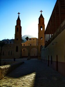
- The Red Sea Monasteries of Saint Anthony and Saint PaulHidden amid the arid Red Sea hills, far from the cities, are Egypt’s two oldest Coptic monasteries – St Paul’s and St Anthony’s. Their origins trace back to the early days of Christian monasticism, observing rituals that have scarcely changed over sixteen centuries. The monasteries are among the holiest sites in the Coptic faith and the oldest in Monasticism traditions.You don’t have to be religious to appreciate their tranquil atmosphere and imposing setting, however, and there’s also scope for bird watching in the vicinity. Birdlife – hoopoes, desert larks, ravens, blue rock thrushes and pied wagtails – is surprisingly abundant, and you might glimpse some shy gazelles. What to see: The Monastery of St. Anthony was founded shortly after St. Anthony’s (the founder of monasticism in Egypt) death in the 4th century AD. The monastery was restored during the 12th century by Coptic monks. Inside the monastery is effectively a self-contained village complete with lanes of two-storey dwellings, churches, mills and gardens of vines, olives and palms, surrounded by lofty walls with an interior catwalk, and a library of over 1600 manuscripts, all structures covered an area of 60,000 sq. m.(15 acres), with 25 resident monks. You will face 1158 steps (a 45 minute walk) up to the cave 680m (2231 ft.) above the Red Sea, where St. Anthony lived at the age of 19. The stunning views from the top reward your effort: Technicolour valleys and massifs spill down into the azure gulf, with Sinai’s mountains rising beyond. The Monastery of St. Paul has always been overshadowed by St Anthony’s. Dating to the 4th century, its titular founder St. Paul was only 16 and an orphan when he fled Alexandria to escape Emperor Decius’ persecutions, making him the earliest known hermit. The monastery was a form of posthumous homage by Paul’s followers; its turreted walls are built around the cave where he lived for decades. The monastery complex is much smaller than St Anthony’s and a little more primitive looking. It boasts 4 churches, but the Church of St Paul is its spiritual centre, a cave-church housing the remains of the saint. There is also a two days hiking trip, which offers visitors the chance to experience the peace and tranquillity of the empty desert and its green oasis. The popular image of the desert is of endless seas of sand. However, the vast expanse of rock in the interior of the desert is considered just as important and wondrous in its own right. You’ll have a chance to feel the adrenaline rush while hiking in the desert and you’ll feel the childlike wonder when you spot indigenous wildlife in the area. While camping out in the desert, you’ll experience one of the clearest night skies around as you sit in front of the camp fire and drink Bedouin tea then enjoy a traditional dinner. Red Sea and South Sinai Mountains and Valleys, including hiking The South Sinai Mountains are full of fabulous views, and what better way to experience them than through hiking? Though your legs may feel tired at times, you will be rewarded with stunning views and fresh mountain air, which will make you forget your tiredness in no time The satisfaction of arriving at your destination, pushing the limits, and experiencing a new challenge on this great adventure will be an amazing story to tell when you return home. St Catherine’s Monastery lies in the heart of South Sinai’s high mountain region, and the surrounding area is an ideal trekking destination. If you are staying in Sharm el Sheikh or Dahab you still can hike in this area as it is only about 3 hours drive from those cities. The rugged interior of the desert is populated by barren mountains, wind-sculpted canyons, and wadis that burst into life with even the briefest rains. The rocks and desert landscapes turn shades of pink, ochre(green), and black as the sun rises and falls, and what little vegetation there is appears to grow magically out of the rock. The desert contains numerous peaks over 2000m (6562 ft.). Snow frequently covers the ground in winter and flash floods can occur all year round. Bedouin often live in these mountainous areas, tending their sheep and goats. Their resourcefulness and freedom is incomparable and has allowed them to survive in South Sinai’s harsh and arid lands. The wildlife here includes gazelles, foxes, ibexes, small rodents, and lizards. There are also a large number of birds, such as seagulls, falcons, herons, and other migratory species. The flora consists mostly of large acacia trees and small shrubs. The variety of these shrubs are very interesting, with over 80 species, 34 of which are endemic, and only found in this region. Enjoy the atmosphere of this quiet desert, far away from tourism, for a period of reflection, of contemplation, to find inner peace and harmony. What to see: St Catherine Monastery: Mount Sinai, also known as Moses’ mountain, is revered by Christians, Muslims, and Jews alike, as it is believed that God delivered his Ten Commandments to Moses at its summit. There are three different routes up to the summit – the Camel Trail, which is the most common, the Steps of Repentance, and the longest but the most beautiful hike Al Arbaeen Valley. Arbaeen Valley lies to the west of Moses’ Mountain and has impressive rock formations and beautiful scenery. A small Bedouin community lives in the valley and has become famous for raising an animal that was almost extinct in South Sinai, known as a Rock Hyrax. Halfway in the valley lays a rock which Moses is believed to have struck to create 12 springs in order to maintain the Children of Israel during the Exodus. Egypt’s highest peak, St Catherine Mountain (2642m – 8667ft), lies 6 km south of Mount Sinai. According to traditions, it was on this peak that monks found the intact body of St Catherine, the peak can be reached on foot in 5 to 6 hours. On the summit are a chapel, a meteorological station, and 2 rooms for pilgrims to stay overnight. The summit offers a great panoramic view over the Sinai Peninsula. Ain Khudra is a very small oasis located 12 km (7.5 miles) north of Nuweiba. Ain Khudra is a very beautiful oasis, with palm and guava trees, and hot water coming up from the ground. The lack of people here (only a few Bedouin and their goats) offers a tranquil part of Egypt, a total contrast to the big cities. The longest valley in Sinai and the main route between the Gulf of Suez and Saint Catherine is the Feirn Valley. It has Sinai’s largest oasis with more than 12,000 date palms. Mount Serbal is the most important attraction and was believed by early Christians to have been the real Moses’ Mountain. Another important attraction is The Seven Sisters Nunnery. One of the oldest man-made structures found in Sinai are the Nawamis, a series of stone tombs made from sandstone. The bones found inside these tombs date back to between 4000 and 3150 BC. The Colored Canyon lies between St Catherine and Nuweiba. It derives its name from the layers of bright, multi-colored stones that resemble paintings on its steep narrow walls. The White Canyon is smaller than the colored canyon. It runs between steep walls displaying incredible rock formations and ends at a sandy valley. Abbas Basha Mountain is where the ruins of the palace built by the 19th-century king Abbas Hilmi I lie. Reaching the summit rewards you with stunning views. Shag Valley offers luscious vegetation, springs and water holes. Sarabit al Khadim can be reached from Abu Zenima or Wadi Feiran. It is famous for a ruined Pharaonic Temple surrounded by ancient turquoise mines and starkly beautiful landscape. Mukattab Valley, known by the name Valley of Inscriptions, hosts Sinai’s largest collection of rock inscriptions and stela, some dating back to the 3rd dynasty.
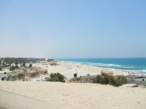
- El ArishCURRENTLY, TOURIST VISITS ARE BANNED Al-Arish, the capital and largest city of the Governorate of North Sinai, as well as the largest city of the Sinai Peninsula, is home to around one million inhabitants. The city is distinguished by its clear blue water and Mediterranean waves that lap at the soft white sand which stretches across an area of around 10km (6 miles) from East to West. The fruitful palm wood lines the coast and is accompanied by the bright colours of the Bedouin crafts. The city is a popular weekend getaway for holidaying Cairo residents in the summer. Not only is Arish a spectacular destination for holidays, but it also has some military importance. Arish is located on the Horus military route which was used by the Pharaohs during their campaigns around Palestine and Asia Minor, giving Al Arish strategic importance. What to see: The Al-Arish Museum is a massive, fortress-like building on the outskirts of the city. The exhibits present a full timeline of Egypt’s history, from the Pharaonic times, all the way through to the Islamic era, and are thoughtfully displayed. A smaller museum, The Sinai Heritage Museum, was established in order to educate visitors to the peninsula about traditional Nomadic life in Sinai. The displays show Bedouin tools, handicrafts, clothing and traditional medicines. Also known as Tell el-Farma, the Pelusium City was established as early as the Pharaonic civilization and was an important transit point for people travelling from Egypt to Palestine and Syria. It became an important port and also a trade and cultural centre under the Romans and remained as such until the early Christian period. It was traditional for the Holy Family to stop at Pelusium during the flight to Egypt. The Farma Citadel has 36 defence towers constructed by the Abbasid ruler al-Mutawakel Ala Allah around 930 AD. The Al-Arish citadel was built on a hillside South-west of Al-Arish, on the ruins of a Pharaonic fort. The fort has been demolished, leaving only two towers and the Eastern wall. It was constructed by the Turkish Sultan, Solimamn el-Qanouny in 1568, restored by Bonaparte’s troops in 1799, and destroyed by British bombers during World War I. East of Al-Arish is the 220 square km (85 sq miles) Zerenike Protectorate, a haven for migrating birds, and a great destination for nature lovers and birdwatchers. Over 270 avian species can be spotted here, and for most of the year, it is possible to see flamingos. Held every Thursday is the colourful Bedouin Market. The weekly market draws in thousands of Bedouin traders from all over the peninsula, and they arrive en masse for the occasion. Veiled women trade their silver, beadwork and embroidered dresses. Squeezing between the bleating goats, the chicken cages and the huge mounds of onions and spices, whilst trying to manoeuvre through the teeming crowd is an exciting and chaotic experience. NOTE: Al-Arish is currently not accessible for tourists. Red Sea diving Safari The Red Sea boasts world-class diving and magical crystal clear water visibility all year round, with a rich, diverse marine life and a great variety of dive sites including wreck, wall, and drift dives. The most interesting dive sites of The Red Sea are some of the biggest and most impressive adventures in a diver’s life. For the diving community across the world, the Red Sea is considered a diving sanctuary, and it has been the diving community that has been most vocal and active towards environmental issues in the south. The region has gained a strong reputation amongst the international diving community due to its world-class reef topography, marine biodiversity, and pristine dive sites along the coastline and offshore. Sightings of spinner dolphins, dugongs, turtles, mantas, and sharks are frequent. The Red Sea is an ideal destination for all divers. Dive programs here are designed to accommodate any level diver from beginner to advanced. Sharm El Sheikh and Hurghada are the most famous destinations in the Egyptian Red Sea, but other destinations such as Ain Sokhna and Marsa Alam are gaining popularity. There are day and half day dive and snorkelling cruises, while liveaboards offer multiple days during which to visit dive sites that less divers reach.