Kharga Oasis
Kharga Oasis is Egypt’s largest oasis, with a depression of around 376,505 km2 (145,174 miles2), which has been inhabited since prehistoric times. Its modern city, Qasr Kharga, houses 200,000 people including 1,000 Nubians who moved here after the creation of Lake Nasser. It is the nearest of the oases to Luxor and the capital of the New Valley Governorate (comprising of Kharga, Dakhla, and Farafra oases).
In ancient times, a lake occupied a large part of the depression and the thick deposits of sandy clay then lay down, which now forms the bulk of the cultivated land.
Historical references to expeditions into Kharga Oasis go back as far as the Old Kingdom, but little evidence remains in Kharga today of life in the Pharaonic times.
The chain of at least 20 forts, which vary in size and function from large settlements to garrison towns, indicates its importance through the ages.
The practice of using Kharga Oasis as a colony for exiles continued throughout Roman times and into the Christian era.
Many early Christian bishops were banished here and the oasis soon became a refuge for Christian hermits who often lived in isolated tombs or caves in the desert.
Kharga is connected to the Nile Valley by two main routes, one from Armant, near Luxor, to Baris, in the South of the region, and the second from Asyut to Kharga City in the North.
The main source of income in the oasis is from agriculture, the cultivation of dates, cereals, rice, and vegetables, which are sent to markets in the Nile Valley. Kharga’s main craft is basket and mat-making from the leaves and fibers of the palm trees.
Dates play an important part in the social calendar. The City Day (Oct 3) celebrates the beginning of the date harvest, and the marriage season is also timed to coincide with the flowering of the date crop (from July until harvest time).
What to see:
The Museum of the New Valley was designed to resemble the architecture of nearby Bagawat Coptic Necropolis. This two-story museum houses a small but interesting selection of archaeological finds from around Al-Kharga and Dakhla Oases.
Al-Bagawat Necropolis is one of the earliest surviving and best-preserved Christian cemeteries in the world.
Consisting of 263 mud-brick chapels spread over a hilltop, it was used for Christian burials between the third and sixth centuries (it was later used by the followers of Bishop Nestorius, who was exiled to Kharga for heresy). The chapels embody diverse forms of mud-brick vaulting or Roman-influenced portals but are best known for their Coptic murals.
A few have vivid murals of biblical scenes inside and some have ornate facades. Adam and Eve, Noah’s Ark, Abraham, and Isaac populate the dome of the fifth-century Chapel of Peace near the entrance to the necropolis. Further north, Roman-looking pharaonic troops pursue the Jews, led by Moses, out of Egypt, in the Chapel of the Exodus. In the center is a church dating back to the 11th century AD.
Al-Kashef Monastery, named after a Mamluke governor, has been strategically placed to overlook what was one of the most important crossroads of the Western Desert – the point where the Darb al-Ghabari from Dakhla crossed the Darb al-Arba’een.
The magnificent mud-brick remains date back to the early Christian era. Once five stories high, much of it has collapsed, but you can see the tops of the arched corridors that crisscrossed the building.
In the valley below you can see the ruins of a small church or hermitage, with Greek texts on the walls of the nave and the tiny cells where the monks slept.
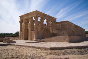
Hibis Temple is the largest temple in any of the oases.
The town of Hibis was the capital of the oasis in the ancient days, but all that remains today is the well-preserved limestone temple, once sitting on the edge of a sacred lake.
Dedicated to the God Amun-Re, construction of the temple began during the 26th dynasty, reign of the ruler Psammetichus II (595-589 BC), though the temple was enlarged and the decorations and a colonnade were added over the next 300 years, till the reign of Ptolemy II (285-343 BC).
The temple is well preserved and contains an avenue of sphinxes and an eight-columned pavilion. Entering through the four gateways brings you to the colonnaded court, the hypostyle hall, and the sanctuary. The temple was reconstructed after a $20 million conservation fiasco when it was dismantled to move it to higher ground.
Qasr Al Ghweita Temple (fortress of the small garden) is a fortified hilltop temple from the late period with a commanding view of the area, which was intensively farmed in Ancient Times.
Its 10m (33 ft.) high walls enclose a sandstone temple dedicated to the Theban Triad (Amun, Mut, and Khonsu), built by Darius I, 27thDynasty, and was completed by the Ptolemeis (Ptolemy III, IV, and X).
The temple ruins include a pronaaos with elegant columns, a hypostyle hall, and a sanctuary. It was later incorporated into a fortress during the Roman period.
Qasr Al-Zayan Temple is a Roman temple that lends its name to a still-thriving village built over the ancient town of Tchonemyris, one of the largest and most important ancient settlements in Kharga Oasis. The ruins of which have not yet been excavated.
This proximity to daily life helps you imagine it as a bustling settlement in antiquity.
Dedicated to Amun-Re, the temple is enclosed within a mud-brick fortress, together with living quarters for the garrison, a cistern, and a bakery. The plain hereabouts is 18m. (59 ft.) Below sea level, the lowest point in Kharga Oasis.
It was constructed during the Ptolemaic time and there is an inscription that indicates that the temple was restored during the reign of Emperor Antoninus (138-161 AD).
Nadura Temple is situated on a 135 m. (443 ft.) high hill in the desert. Its eroded sandstone wall and pronaos aren’t anything special, but it has strategic views of the area and once doubled as a fortified lookout, as suggested by its name, Nadura, meaning ‘lookout’.
Built during the reign of Roman emperor Antoninus Caesar (138-161 AD), Nadura is typical of the Roman temple-forts that once protected the oasis from desert raiders. Even though it is now badly ruined, the superb vistas here are ideal for sunset adulation.
Al-Deir Fort is the best-preserved and most accessible of Kharga’s Roman forts, which once guarded the caravan route at “Darb al-Arba‘ in the forty-day track to the Nile.
Built during the reign of the Byzantine emperor Diocletian (284–305 AD), the fort was built of mud brick, and its twelve rounded towers are connected by a gallery, with numerous rooms featuring graffiti drawn by generations of Roman, Coptic Christian, Turkish, and British soldiers.
Its name means ‘monastery’, and was used as such during the Christian era. Later, both Turkish and British troops occupied the fortress.
There is a necropolis and the ruins of a church to the west of the fortress. Around the fortress are the ruins of an ancient town where two buildings still stand. The escarpment is the small temple that was later used as a church.
The abandoned railway visible in the distance was built by the British between 1906 and 1908, but it has been gradually blocked by advancing dunes.
Qasr Al-Labeka Settlement lies in an isolated part of the desert. It was built by the Romans at the other end of the caravan route.
It is the nearest site where you can see the amazing system of underground aqueducts, known as manafis that drew on groundwater like the qanats of ancient Persia.
The site contains two temples that lie half-buried in the sand, an imposing fort, and a group of decorated tombs. Several buildings once surrounded the fortress and to the south are the silted remains of a large well, an ancient spring, still surrounded by palm, acacia, and tamarisk trees, which would have provided water for the fort and settlement.
The size of the well suggests that a large community lived here, which was served by a series of aqueducts, built to take the water out to the cultivated fields. But the fortress itself has never been excavated.
In Gebel al-Tayr, “the Mountain of the Birds”, there is graffiti and inscriptions dating to as early as prehistoric times. However, on the western side, a path leads to the top of the mountain through a grotto, and here, Coptic paintings, prayers, and invocations dating from the fourth, fifth and tenth centuries may be found. These inscriptions, which include Demotic and Greek script, were mostly left by hermits who lived in the surrounding caves and can be identified by a cross.
At the top of this mountain, we find the Cave of Mary, obviously a sacred site during The Christian Era. There is considerable graffiti, including some that predate The Christian era, but among the etchings is a painting of The Madonna and Child, along with a prayer in alternating red and yellow lines.
Ain Umm Dabadib Village is the largest and oldest Roman/Byzantine village in the oasis, covering over 200 sq. km (77 sq. mi.). It includes a ruined Roman mud-brick fortress, ruins of Byzantine churches and tombs, but is most remarkable for its underground aqueducts, the deepest being 53m (174 ft.) beneath the surface and the longest-running is 4.6 km long (3 mi.), with vents for cleaning and repairs every few so often that are covered by large, flat stones. The site is typical of oases fortresses, which were always near a spring.
Baris Oasis is named after the French capital, though its foraging goats and unpaved streets make a mockery of a billboard welcoming visitors to “Paris”.
It was once one of the most important trading centers along the 40-day track “Darb al-Arba’een”, but there is little left to remind you of that.
There is little to see apart from the mud-brick houses of “Baris al-Gedida”, north of the original town.
Hassan Fathy, Egypt’s most influential modern architect, designed the houses using traditional methods and materials and intended Baris al-Gedida to be a model for other new settlements, but work stopped at the outbreak of the Six-Day War of 1967 and only two houses and some public spaces have ever been completed.
Dush Temple and Fortress is an imposing Roman temple-fortress completed around 177AD, on the site of the Ancient town of Kysis.
Dush was a border town strategically placed at the intersection of five desert tracks of caravan routes and one of the southern gateways to Egypt.
As a result, it was solidly built and heavily garrisoned, now partially buried in the sands, with mud-brick walls up to 6 m. (20 ft.) high, with four or five more stories lying underground. A 1st-century sandstone temple abutting the fortress was dedicated to Isis and Serapis.
The gold decorations that once covered parts of the temple and earned it renown have long gone, but there is still some decoration on the inner stone walls.
The fortress formerly protected the Ancient town of Kysis, an agricultural settlement enriched by the 40 Days Road that had potters, jewelers, and brothels.